About Bargarh
ବରଗଡ଼ ବିଷୟରେ
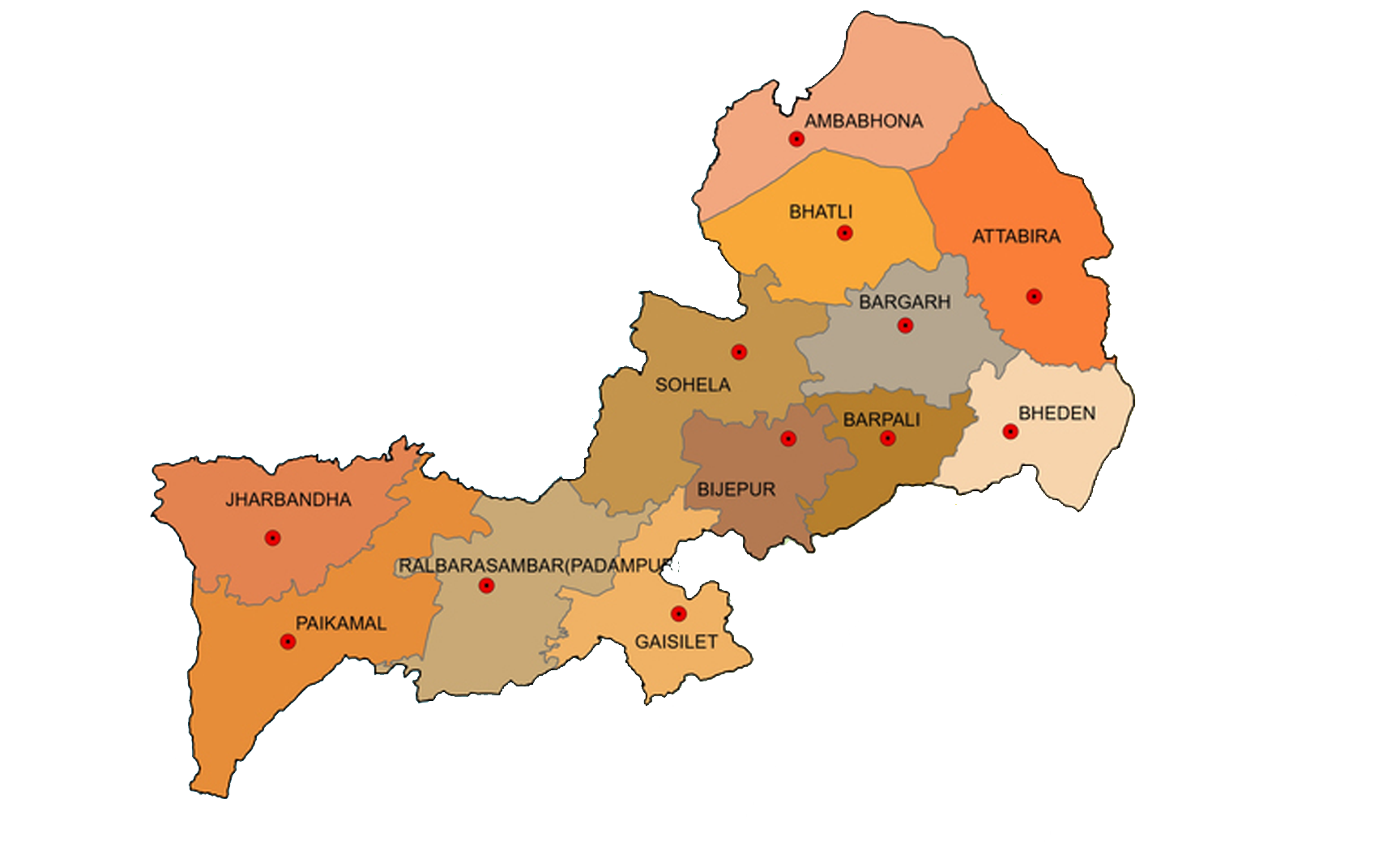
The Bargarh district lies between 20.20.0″ North latitude and 83.37.15″ East longitude. It is one of the western most districts of the State of Orissa and came in to existence as a district from 1st April 1993. It is bounded on the north by the State of Chhatisgarh and on the east by the district of Sambalpur, on the south lies the district of Balangir and Subarnapur and on the west the district of Nawapara. The district has an area of 5834 Sq.Kms.
The Bargarh district can be divided into 3 natural divisions, (1) Bargarh Plain (2) Borasambar (3) Ambabhona & Lakhanpur. The greater portion is an open plain of considerable fertility drained by the Danta and the Jira, the two tributaries of Mahanadi. To the north of this plain runs the Barapahar range of hills and to the south-west lie the valley of river Ong (Ang).
୧୯୯୩ ଏପ୍ରିଲ ପହିଲାର ବରଗଡ ଏକ ସ୍ୱତନ୍ତ୍ର ଜିଲ୍ଲାସ୍ୱୀକିତ ପାଇଛି । ଉର ଦିଗରେ ଛତିଶଗଡ ରାଜ୍ୟ, ପୂର୍ବରେ ସମ୍ବଲପୁରଜିଲ୍ଲା, ଦକ୍ଷିଣରେ ବଲାଙ୍ଗିର ଏବଂ ପଶ୍ଚିମରେ ନୂଆପଡା ଜିଲ୍ଲା ବରଗଡର ୫୮୩୪ ବର୍ଗକିଲୋମିଟର ଏକ ବିଶ୍ଚିଷ୍ଟ ଭୂଖଣ୍ଡର ସ୍ୱାତନ୍ତ୍ୟ ବହନ କରୁଛି । ବରଗଡ ଜିଲ୍ଲାକୁ ତିନୋଟି ପ୍ରାକୃତିକ ବିଭାଗରେ ବିଭାଜିତ କରାଯାଇପାରେ । ସେଗୁଡିକ ହେଉଛି, ବରଗଡ, ବୋଡାସମ୍ବର, ଅମ୍ବାଭୋନା ଏବଂ ଲଖନପୁର । ଦନ୍ତା ଓ ଜିରା ଏଜିଲ୍ଲାର ବିଶିଷ୍ଟ ନଦୀ ଏବଂ ଏହି ଉଭୟ ନଦୀ ମହାନଦୀରେ ମିଶିଛନ୍ତି । ବରଗଡଜିଲ୍ଲାର ବିଶେଷତ ୍ୱହେଉଛି ଏହାର ଷ ଉପଯୋଗୀ ମାଟି । ଉଚ୍ଚ ପାର୍ବତ୍ୟାଞ୍ଚଳକୁବକ୍ଷରେ ଧରିଥିବା ବୋଡାସମ୍ବର ନିଜକୋଳରେ ଅଙ୍ଗନଦୀର ଅବବାହିକାକୁ ବେଶ ଯତ୍ନ ସହକାରେ ପାଳନ କରିଛି । ବରଗଡରୁ ବିଭିନ୍ନ ରହିଥିବା ଅମ୍ବାଭୋନା ଏବଂ ଲଖନପୁର ବାରପାହାଡ ର ଗୌରବ ରେଗୌରବାହିତ ।
The Bargarh plain is not a flat alluvial tract but an expanse of undulating country sloping down from the Barapahar hills in the north, to the Mahanadi valley in the east. It contains a good portion of the cultivated land of the district and its undulating character affords excellent scope for irrigation reservoirs. The soil is a mixture of sand and gravel as well as of clay. Its a good rice soil and unlike the more fertile black cotton soil it grows few seeds and does not harbour dangerous insect pests. This tract is nowhere bare of vegetation and the villages are found embowered with mango groves.
The Borasambar (Padampur) tract lies to the south-west of the Bargarh plain. It is bounded by the high hills on the north and south and the intervening plain is drained by river Ong (Ang), the valley of which particularly in the eastern portion is best suited to agriculture. Its soil contains some river slit and enriched by hill drainage.
History
ଇତିହାସ
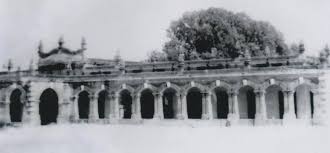
The headquarter of the district Bargarh is situated on the left bank of Jira River. The town Bargarh is on the National Highway-6. The original name of the place was “Baghar Kota” as known from an inscription of the 11th Century A.D. It was called “Bargarh” probably from the time of Balaram Dev, the Chauhan Raja of Sambalpur, who made it for some time his headquarters and constructed a big fort for its protection. Narayan Singh, the last Chauhan Raja granted this place in “Maufi” (free hold) to 2 Brahmin brothers Krushna Dash and Narayan Dash, sons of Baluki Dash who was killed in action by the Gond rebels led by Baldia Ray and Mahapatra Ray. The another part of the district popularly known as “Borasambar” was formerly the headquarters of the Borasambar Zamindari extending over 2178 Sq.Kms. Later, the headquarters of the Zamindari shifted to Padampur, one of the present sub-divisional headquarter. The Zamindar belongs to the Binjhal family and is called Pat-Bariha.
ବରଗଡଜିଲ୍ଲା ଜୀରାନଦୀ ର ବାମ ପାଶ୍ୱର୍ରେ ଅବସ୍ଥିତ । ଜାତୀୟ ରାଜପଥ ୬ ବରଗଡଜିଲ୍ଲା ତଥା ସହରରେ ଗୌରବ ବୃଦ୍ଧିକରିଆସୁଛି । ବରଗଡର ପ୍ରକୃତ ପ୍ରାଚୀନ ନାମହେଉଛି “ବଘାରକେଟା” ଯାହା ୧୧ଶତାଦ୍ଧୀର ଶିଳାଲେଖରୁ ଜଣାଯାଏ । ବଳରାମ ଦେବଙ୍କ ସମୟରୁ ଏହା ବରଗଡ ଭାବରେ ନାମିତ ହୋଇଛି । ବରଗଡଜିଲ୍ଲାର ଏକ ବିଶିଷ୍ଟ ଭୂଖଣ୍ଡ ହେଉଛି ବୋଡାସମ୍ବର,ଯାହା ବୋଡାସମ୍ବର ଜମିଦାରର ସଦର ମହକୁମା ଭାବରେ ଗଢିଉଠିଥିଲା । ଏହା ମଧ୍ୟ ୨୧୭୮ ବର୍ଗ କିଲୋମିଟର ବିଶିଷ୍ଟ ଏକ ବିଶାଳ ଭୂଖଣ୍ଡ ।